![](/images/other/stat-length.png)
![Randonnée Marche Ventalon en Cévennes - Tras Lou Serre St Andeol de Clerguemort - Photo](https://media.geolcdn.com/t/1900/400/ext.pjpeg?maxdim=2&url=https%3A%2F%2Fstatic1.geolcdn.com%2Fsiteimages%2Fupload%2Ffiles%2F1553511878bg_sport_marche.png)
Tras Lou Serre St Andeol de Clerguemort
ajasse
Utilisateur
![Longueur](/images/other/stat-length.png)
Longueur
16,8 km
![Altitude max](https://static1.geolcdn.com/siteimages/upload/files/1508320355ic_sort_altitude_max_24dp.png)
Altitude max
907 m
![Dénivelé positif](https://static1.geolcdn.com/siteimages/upload/files/1508320355ic_sort_den_pos_24dp.png)
Dénivelé positif
669 m
![Km-Effort](/images/other/stat-length.png)
Km-Effort
26 km
![Altitude min](https://static1.geolcdn.com/siteimages/upload/files/1508320355ic_sort_altitude_min_24dp.png)
Altitude min
404 m
![Dénivelé négatif](https://static1.geolcdn.com/siteimages/upload/files/1508320355ic_sort_den_neg_24dp.png)
Dénivelé négatif
660 m
![Boucle](https://static1.geolcdn.com/siteimages/upload/files/16400158638029165_repeat_loop_refresh_sync_direction_icon.png)
Boucle
Oui
Date de création :
2019-05-27 08:50:06.704
Dernière modification :
2019-05-27 20:06:49.464
![Marche](https://static1.geolcdn.com/sitytour/trail-icons/101.png)
5h39
Difficulté : Difficile
![Scannez ce code QR pour ouvrir la randonnée dans l'application SityTrail](https://capi.geolives.com/qq0zvz2zws4bq2lad0pu/sitytour/trails/2096106/qr.png?size=200)
Application GPS de randonnée GRATUITE
À propos
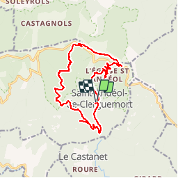
Randonnée Marche de 16,8 km à découvrir à Occitanie, Lozère, Ventalon en Cévennes. Cette randonnée est proposée par ajasse.
Description
Départ à Lezinier sous le temple de St Andeol de Clerguemort (difficile à trouver).
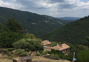
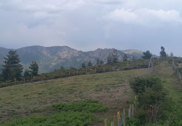
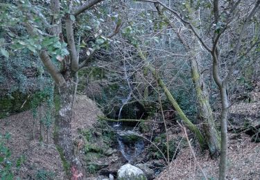
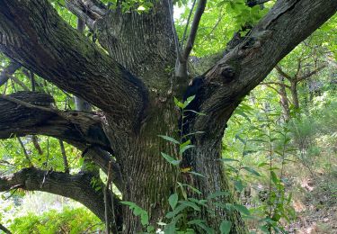
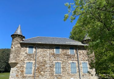
Découverte du patrimoine cévenol.
Architecture rurale, Châtaigneraies.
Localisation
Pays :
France
Région :
Occitanie
Département/Province :
Lozère
Commune :
Ventalon en Cévennes
Localité :
Saint-Andéol-de-Clerguemort
Départ:(Dec)
Départ:(UTM)
572298 ; 4904681 (31T) N.
Commentaires
Randonnées à proximité
![Randonnée Marche Vialas - Sentier de l'Avès depuis le Coupétadou - Photo](https://media.geolcdn.com/t/375/260/ext.jpg?maxdim=2&url=https%3A%2F%2Fservices.sitytrail.com%2FGeolivesWS%2FDownloadMedia.ashx%3FTrailID%3D616629%26Media%3D20160818152623.jpg)
![Marche Marche](https://static1.geolcdn.com/sitytour/trail-icons/101.png)
Sentier de l'Avès depuis le Coupétadou
Marche
Moyen
(1)
Vialas,
Occitanie,
Lozère,
France
![](/images/other/stat-length.png)
15,3 km | 23 km-effort
4h 51min
![](https://static1.geolcdn.com/siteimages/upload/files/16400158638029165_repeat_loop_refresh_sync_direction_icon.png)
Oui
![Randonnée Marche Ventalon en Cévennes - Sentier de l'Avès - Photo](https://media.geolcdn.com/t/375/260/bb007248-100a-4dc9-b839-07facd88bc96.jpg&format=jpg&maxdim=2)
![Marche Marche](https://static1.geolcdn.com/sitytour/trail-icons/101.png)
Sentier de l'Avès
Marche
Moyen
Ventalon en Cévennes,
Occitanie,
Lozère,
France
![](/images/other/stat-length.png)
14,7 km | 22 km-effort
4h 24min
![](https://static1.geolcdn.com/siteimages/upload/files/16400158638029165_repeat_loop_refresh_sync_direction_icon.png)
Oui
![Randonnée Marche Génolhac - Vallée de l'Homol - Photo](https://media.geolcdn.com/t/375/260/6da51f23-b6c0-4f07-88d5-b7f87324ef05.jpg&format=jpg&maxdim=2)
![Marche Marche](https://static1.geolcdn.com/sitytour/trail-icons/101.png)
Vallée de l'Homol
Marche
Difficile
(2)
Génolhac,
Occitanie,
Gard,
France
![](/images/other/stat-length.png)
16 km | 24 km-effort
5h 5min
![](https://static1.geolcdn.com/siteimages/upload/files/16400158638029165_repeat_loop_refresh_sync_direction_icon.png)
Oui
![Randonnée Marche Vialas - sud Mont Lozère de Vialas - Photo](https://media.geolcdn.com/t/375/260/f84d4d4c-c02a-465e-803e-7fcc56bba63b.jpg&format=jpg&maxdim=2)
![Marche Marche](https://static1.geolcdn.com/sitytour/trail-icons/101.png)
sud Mont Lozère de Vialas
Marche
Difficile
Vialas,
Occitanie,
Lozère,
France
![](/images/other/stat-length.png)
17,5 km | 29 km-effort
6h 4min
![](https://static1.geolcdn.com/siteimages/upload/files/16400158638029165_repeat_loop_refresh_sync_direction_icon.png)
Oui
![Randonnée Marche Saint-Privat-de-Vallongue - 48 le pont de champermal le 06/02/25 - Photo](https://media.geolcdn.com/t/375/260/e61f9507-a772-4062-89e7-53c21ae774bc.jpg&format=jpg&maxdim=2)
![Marche Marche](https://static1.geolcdn.com/sitytour/trail-icons/101.png)
48 le pont de champermal le 06/02/25
Marche
Très difficile
Saint-Privat-de-Vallongue,
Occitanie,
Lozère,
France
![](/images/other/stat-length.png)
13,9 km | 21 km-effort
6h 44min
![](https://static1.geolcdn.com/siteimages/upload/files/16400158638029165_repeat_loop_refresh_sync_direction_icon.png)
Oui
![Randonnée Marche Vialas - Vialas - Photo](https://media.geolcdn.com/t/375/260/f860d80d-28b3-4768-b15b-59a1802c92c8.jpg&format=jpg&maxdim=2)
![Marche Marche](https://static1.geolcdn.com/sitytour/trail-icons/101.png)
![Randonnée Marche Vialas - Sentier de l'Avès depuis le Coupétadou - Photo](https://media.geolcdn.com/t/375/260/ext.jpg?maxdim=2&url=https%3A%2F%2Fservices.sitytrail.com%2FGeolivesWS%2FDownloadMedia.ashx%3FTrailID%3D616623%26Media%3D20160818150409.jpg)
![Marche Marche](https://static1.geolcdn.com/sitytour/trail-icons/101.png)
Sentier de l'Avès depuis le Coupétadou
Marche
Moyen
Vialas,
Occitanie,
Lozère,
France
![](/images/other/stat-length.png)
15,3 km | 23 km-effort
4h 51min
![](https://static1.geolcdn.com/siteimages/upload/files/16400158638029165_repeat_loop_refresh_sync_direction_icon.png)
Oui
![Randonnée Marche Chamborigaud - Vallée du Luech et vallée de l’Homol - Photo](https://media.geolcdn.com/t/375/260/b5b3dc23-c582-423d-9243-6c045f9b5cf5.jpg&format=jpg&maxdim=2)
![Marche Marche](https://static1.geolcdn.com/sitytour/trail-icons/101.png)
Vallée du Luech et vallée de l’Homol
Marche
Très difficile
Chamborigaud,
Occitanie,
Gard,
France
![](/images/other/stat-length.png)
19,9 km | 29 km-effort
6h 31min
![](https://static1.geolcdn.com/siteimages/upload/files/16400158638029165_repeat_loop_refresh_sync_direction_icon.png)
Oui
![Randonnée Marche Vialas - Vialas et le Luech - Photo](https://media.geolcdn.com/t/375/260/ext.jpg?maxdim=2&url=https%3A%2F%2Fstatic1.geolcdn.com%2Fsiteimages%2Fupload%2Ffiles%2F1553511878bg_sport_marche.png)
![Marche Marche](https://static1.geolcdn.com/sitytour/trail-icons/101.png)
Vialas et le Luech
Marche
Moyen
Vialas,
Occitanie,
Lozère,
France
![](/images/other/stat-length.png)
8,1 km | 11,8 km-effort
2h 41min
![](https://static1.geolcdn.com/siteimages/upload/files/16400158638029165_repeat_loop_refresh_sync_direction_icon.png)
Oui